


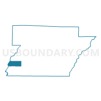
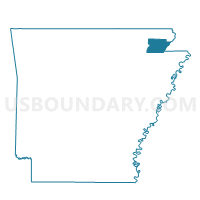
Walnut Corner Voting District, Greene County, Arkansas
About
Outline

Summary
| Unique Area Identifier | 526574 |
| Name | Walnut Corner Voting District |
| County | Greene County |
| State | Arkansas |
| Area (square miles) | 10.36 |
| Land Area (square miles) | 10.36 |
| Water Area (square miles) | 0.00 |
| % of Land Area | 100.00 |
| % of Water Area | 0.00 |
| Latitude of the Internal Point | 36.03978710 |
| Longtitude of the Internal Point | -90.79006680 |
Maps

Graphs
Select a template below for downloading or customizing gragh for Walnut Corner Voting District, Greene County, Arkansas


Neighbors
Neighoring Voting District (by Name) Neighboring Voting District on the Map
- Bryan Voting District, Greene County, AR
- CACHE Voting District, Lawrence County, AR
- PROMISED LAND Voting District, Lawrence County, AR
- Salem Voting District, Greene County, AR
- Shady Grove Voting District, Greene County, AR
Top 10 Neighboring County Subdivision (by Population) Neighboring County Subdivision on the Map
- Salem township, Greene County, AR (965)
- Promised Land township, Lawrence County, AR (425)
- Bryan township, Greene County, AR (192)
- Shady Grove township, Greene County, AR (177)
- Cache township, Lawrence County, AR (145)
- Walnut Corner township, Greene County, AR (113)